According to NOAA, no reference designates one specific shoreline as the "legal" shoreline, numbers for the length of the U.S. shoreline can vary depending on how the shoreline is defined.
US Coastline length? https://www.americanoceans.org/facts/us-coastline-length/
The NOAA shoreline length calculation of 153,646 kilometers (95,471 miles) includes measurements taken in 1930-1940 and 1970. The 1939-40 measurements were determined with a recording instrument on the largest-scale charts and maps available at that time. These measurements included the continental U.S. as well as U.S. territories (Hawaii and Alaska were U.S. territories during this period). Shorelines of the outer coast, offshore islands, sounds, bays, rivers, and creeks were included to the head of the tidewater or to a point where tidal waters narrow to a width of 30.48 meters (100 feet). For the Great Lakes, shoreline lengths were measured in 1970 by the International Coordinating Committee on Great Lakes Basic Hydraulic and Hydrologic Data.
https://www.usgs.gov/media/images/map-us-coastlines
The total length of the tidal shoreline includes measurements of the coastal states (which includes the Great Lakes) as well as outlying U.S. territories and possessions.
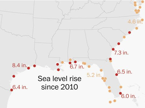
https://www.washingtonpost.com/climate-environment/interactive/2024/sou…