Another winter storm is headed this way: Being prepared is a MUST.
Winter storms sometimes result with millions left without power, heat, or fresh running water. Making preparations before a winter storm is extremely important, since these leave dangerous roads and conditions in their paths.
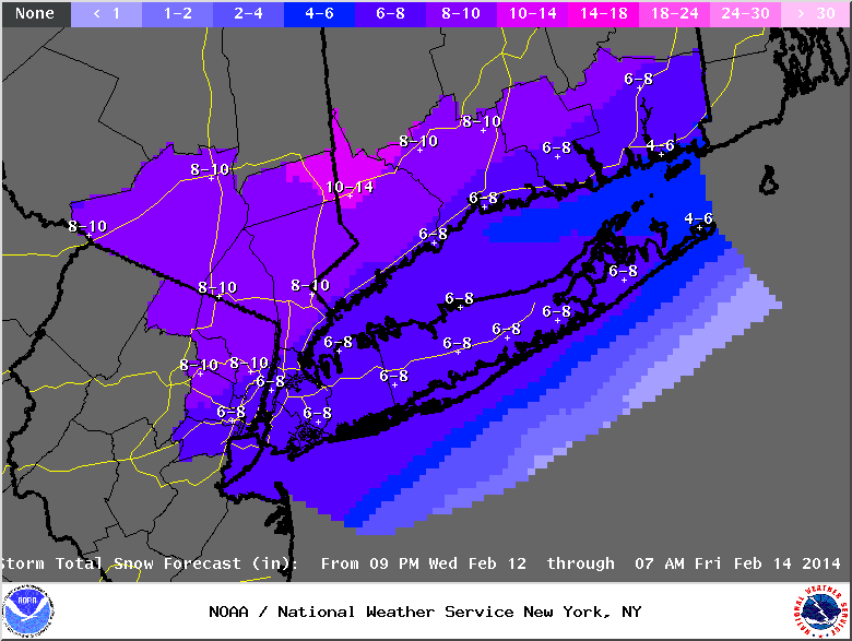
The National Weather Service says the NYC metropolitan area will get hit late Wednesday night through Thursday night. There is a chance that we will get up to eight inches of snow, and possibly mixing with rain on Thursday.
This is very complex weather pattern is taking shape across the southern U.S. and is going to bring a mixture of winter weather hazards, including heavy snow and freezing rain, across the South and Southeast into Wednesday before moving up the Eastern Seaboard, where it will affect parts of the Mid-Atlantic and Northeast Wednesday and then into Friday.
A major winter storm will impact locations from Texas to the southeast coast before it moves up the Eastern seaboard on Wednesday with heavy snow, freezing rain, and heavy rain...Heavy rains and mountain snows expected across the Pacific Northwest and Northern Rockies. Temperatures will be below average east of the Rockies... A strong storm will develop along the Central Gulf Coast and move to the Southeast Coast by Thursday morning.
The system will produce areas of freezing rain and sleet over parts of Eastern Texas and the Lower Mississippi Valley through Wednesday morning. In addition, another area of freezing rain/sleet will develop over parts of the Southeast through Thursday morning. Light to moderate rain will develop over the Lower Mississippi Valley and move eastward to parts of the Southeast while intensifying to moderate to heavy rain on Wednesday. Pockets of snow will
develop over parts of the Southern Appalachians Tuesday night into Wednesday and blossom to heavy snow over parts of the Mid-Atlantic Wednesday night. The heavy snow will expand along the Mid-Atlantic coast into Southern New England by Thursday morning. Furthermore, showers and thunderstorms will develop along the Central Gulf Coast that will move eastward into Florida by Wednesday evening, then ending overnight.
Meanwhile, a front over the Upper Midwest will move slowly eastward to the Upper Great Lakes before stalling on Thursday. The boundary will aid in producing snow over parts of the Northern High Plains, Northern/Central Rockies into the Upper Midwest Tuesday evening moving into the Upper Great Lakes Wednesday into Thursday. A second wave of low pressure will move along the front out of South-Central Canada moving into the Upper Midwest
by Thursday. The wave will bring snow across North Dakota into the Upper Great Lakes Wednesday night into Thursday morning.
Elsewhere, multiple system will move into the Pacific Northwest through Thursday. Onshore flow will accompany the storms, bringing moderate to heavy rain to the coastal areas and snow at high elevations inland with snow and lower elevation rain over parts of the Northern Inter-mountain Region into parts of the Northern Rockies. The snow will expand onto parts of the Northern High Plains by Thursday morning.