Denial has never accomplished a positive outcome. It is time to take notice and never to confuse the public.
Already damaged by human-driven heating could trigger the most powerful ‘Godzilla’ El Niño
- The ocean is already exceptionally warm in the eastern equatorial Pacific, with anomalies above +2°C.
- The atmosphere is responding, not merely the ocean. Westerly wind anomalies, enhanced Pacific convection and strongly negative Southern Oscillation indices are classic signs of a coupled El Niño.
- The +10°C subsurface anomaly is particularly striking. It represents a huge reservoir of unusually warm water beneath the surface that can help sustain or intensify the event.
- NOAA's modeling puts the odds of an extraordinarily strong fall/winter event very high, and specifically gives a 69% chance during October–December of reaching the historic +2.5°C RONI threshold.
- Importantly, strong El Niño does not automatically mean a particular location will experience a particular kind of winter. It shifts probabilities; it doesn't dictate the weather.
El Niño is not only back. El Niño is loading the dice.
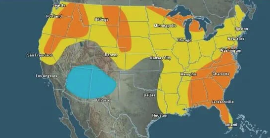
A powerful 2026–27 El Niño could have major implications for the winter storm track, precipitation patterns, temperatures and atmospheric river activity across North America. But the eventual U.S. pattern will also depend on other players, especially the Arctic Oscillation, North Atlantic Oscillation, Pacific jet configuration and the distribution of tropical convection.
https://www.usatoday.com/story/news/weather/2026/08/15/2026-el-nino-winter-forecast-polar-vortex/91219085007/
El Niño is getting stronger, and Winter 2026–27 will become more Interesting than ever.
Because the atmospheric coupling is now confirming that this isn't merely an unusually warm patch of Pacific water. The atmosphere and ocean are beginning to work together as a genuine El Niño machine.
One caveat: because this is an August 2026 forecast looking several months ahead, a 69 percent historic-event is a forecast signal. The following September–October evolution will be a crucial one... Stay tuned.
