
Snow or no, here's what we know. A double Vortex is reloading and Mother Nature says it’s time to blow.
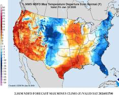
The large-scale pattern is lining up to funnel bitterly cold Arctic air south from Canada at least twice more this January, once this weekend, and again about a week later.
This weather outlook extends nearly two weeks into the future, so exact timing and placement are subject to change. But confidence is increasing that a potentially historic polar vortex outbreak could surge across much of North America toward the end of the month.
If this pattern verifies, some areas could experience temperatures 20 to 40 degrees below average, accompanied by dangerously cold wind chills.
In the shorter term, a fast-moving clipper system drops into the Northern Plains and Upper Midwest by Sunday, bringing snow and strong winds. Snow squalls and localized blizzard conditions are possible, especially in open and rural areas.
Farther east, impactful snowfall is expected along much of the East Coast on Sunday, stretching from the western Florida Panhandle northward to Maine.