NOAA officials predict that nearly two-thirds of the lower 48 states will soon be facing an elevated flood risk through May 2019.
They are warning that Spring flooding becomes unprecedentedly. Following a wet Winter, many parts of the United States of America are at risk of at least minor flooding during this Spring.
In this video, the Climate Prediction Center's Mike Halpert explains what's behind NOAA's temperature, precipitation, and flood outlooks for spring 2019. For maps and more discussion, visit https://www.climate.gov/spring2019.
The video produced by the Climate.gov team in cooperation with climate scientists from the National Oceanic and Atmospheric Administration. Unless specifically stated otherwise, Climate.gov video productions can be freely republished or re-purposed by others.
Nearly two-thirds of the Lower 48 states face an elevated risk for flooding through May, with the potential for major or moderate flooding in 25 states, according to NOAA’s U.S. Spring Outlook issued today. The majority of the country is favored to experience above-average precipitation this spring, increasing the flood risk.
Portions of the United States – especially in the upper Mississippi and Missouri River basins including Nebraska, Minnesota, and Iowa – have already experienced record flooding this year. This early flooding was caused by rapid snowmelt combined with heavy spring rain and late season snowfall in areas where soil moisture is high. In some areas, ice jams are exacerbating the flooding. Offices across the National Weather Service have been working with local communities, providing decision-support services and special briefings to emergency managers and other leaders in local, state and federal government to ensure the highest level of readiness before the flooding began.
Additional spring rain and melting snow will prolong and expand flooding, especially in the central and southern U.S. As this excess water flows downstream through the river basins, the flood threat will become worse and geographically more widespread.
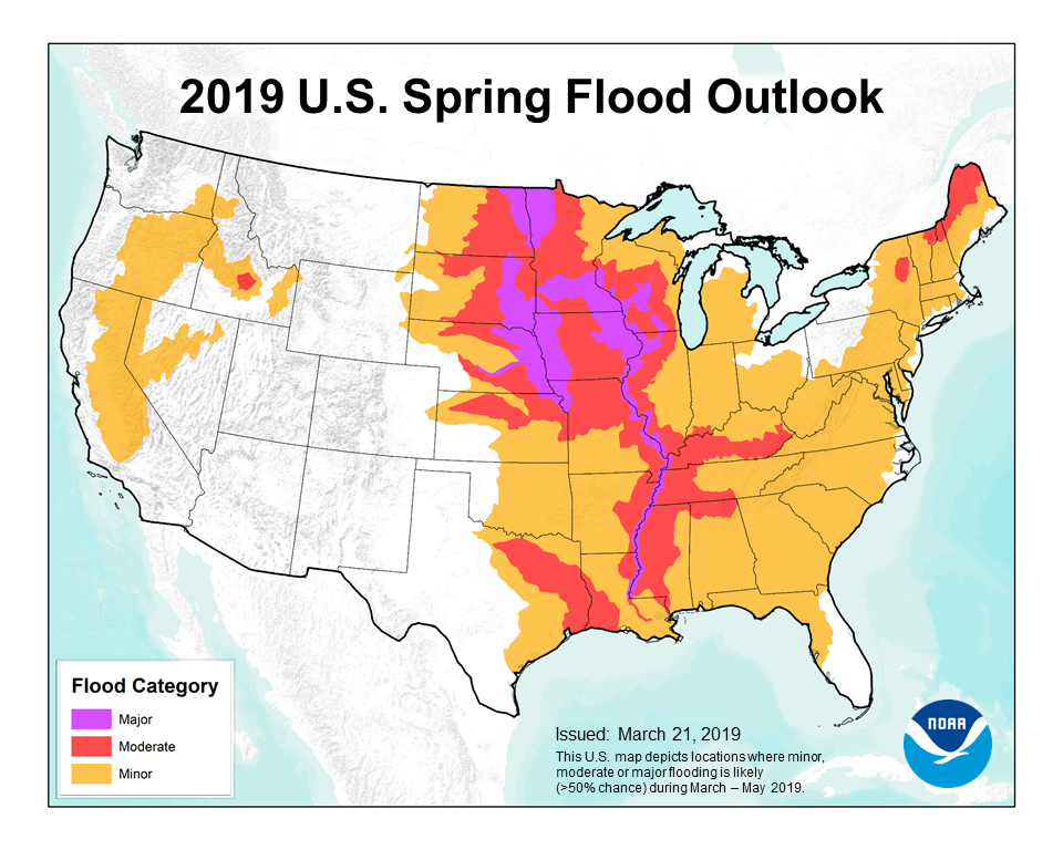
This map depicts the locations where there is a greater than 50-percent chance of a major, moderate or minor flooding during March through May 2019. (NOAA)
“This outlook will help emergency managers and community decision-makers all along the nation’s major waterways prepare people and businesses for the flood threat,” said Neil Jacobs, Ph.D., NOAA’s acting administrator. “In addition to the safety aspects, our rivers are critical to the economic vitality of the nation, supporting commerce, recreation, and transportation. NOAA forecasts and outlooks help people navigate extreme seasonal weather and water events to keep the country safe and moving forward.”
Spring Flood Risk
Record winter precipitation across a large swath of the country has set the stage for the elevated flood risk. The upper Mississippi and Red River of the North basins have received rain and snow this spring up to 200 percent above normal.
The areas of greatest risk for moderate to major flooding include the upper, middle, and lower Mississippi River basins including the mainstem Mississippi River, Red River of the North, the Great Lakes, eastern Missouri River, lower Ohio, lower Cumberland, and Tennessee River basins.
Additionally, much of the U.S. east of the Mississippi River and portions of California and Nevada are at risk for minor flooding.