Climate change grabs the USA by the throat. The mog hampered our lives throughout Asia. Now it’s followed us to America.
Some experts and elected officials say our leaders responded very slowly to the wildfire smoke that pushed air quality to historically unhealthy levels.
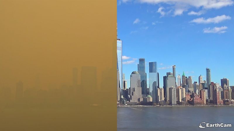
The New York City skyline looked otherworldly this week as a red sun appeared in a dark orange sky. This was a scene transformed by thick smoke that originated from wildfires burning in the Canadian province of Quebec, and it may take a while before it gets better.
Smoke from massive wildfires burning in Canada is filling the sky over the eastern U.S. this week, and AccuWeather meteorologists say the smoke and air quality could get worse.
https://www.youtube.com/watch?v=WGoDaYjdfSg
https://www.youtube.com/watch?v=h8DLofLM7No
https://www.youtube.com/watch?v=hHD2z6XrgcI
Some say it is purple, others see it as lavender but we collectively call it orange haze.
Smoke from Canadian wildfires continues to be transported south by winds into the U.S. resulting in moderate to unhealthy air quality across parts of the Northeast, Mid-Atlantic, Ohio Valley, and Midwest on Friday.
Some improvement is expected this weekend. Excessive rainfall may bring areas of flooding from far northern Washington across central Montana and into western South Dakota Friday.
Air Quality Alerts due to Canadian wildfire smoke remain in effect over parts of the Great Lakes/Ohio Valley to the Northeast and Mid-Atlantic... Additional chances for heavy rain are likely to continue along an axis of anomalous atmospheric moisture content extending from the northern Great Basin to the northern Plains today, which is likely to lead to areas of flash flooding. Saturated soils within the area combined with the potential for a few additional inches of rainfall have prompted a Moderate Risk (level 3/4) of Excessive Rainfall for parts of north-central Montana, where several impacts associated with flooding are possible. Meanwhile, developing thunderstorms are also likely along a quasi-stationary front extending from the northern Plains to the Gulf Coast (draping around a high-pressure system stretched from the Midwest to the Tennessee Valley).
Locally heavy rain and isolated severe thunderstorms are possible along the aforementioned front and to the south throughout the southern Plains. By Saturday, a dry line located across western Texas combined with an upper-level shortwave ejecting out of northwestern Mexico is expected to spark clusters of thunderstorms that could contain large hail, damaging wind gusts, and a few tornadoes as they progress from the southern Plains to the Lower Mississippi Valley. The Storm Prediction Center has issued an Enhanced Risk (level 3/5) of severe weather across northeast Texas and adjacent sections of southeast Oklahoma, southwest Arkansas, and northeast Louisiana. Locally heavy rain is also possible across the same region.
Additionally, isolated flash flooding is possible along the lingering frontal boundary on Saturday as it extends from the Mid-Mississippi Valley to the northern High Plains. As a consolidating area of low pressure develops and progresses across the Ohio Valley on Sunday, areas of heavy rain are possible along a lifting warm front between the Ohio and Tennessee valleys. While the southerly flow increases atmospheric moisture content allowing for the heavy rainfall potential, it will also allow for much of the lingering wildfire smoke in the eastern U.S. to finally subside. However, leading up to the beginning of the weekend near-surface wildfire smoke associated with Canadian fires is expected to continue plaguing regions from the Great Lakes to the Mid-Atlantic with reduced air quality.
Northwesterly flow around a low-pressure system over the Northeast will continue the flow of smoke over the region but should relax and eventually shift to more of a westerly direction on Saturday. Pockets of denser smoke could significantly reduce air quality and lead to lowering visibility, with a wider region of light to moderate smoke leading to an opaque sky and orange sunsets/sunrises. Air Quality Alerts remain in effect from Michigan and Indiana to the northern Mid-Atlantic. Temperatures throughout the Lower 48 into this weekend are expected to feature only a few regions with elevated summertime heat. Above-average temperatures are forecast throughout the Great Plains today before the warm weather shifts to the southern Plains, Mid-Atlantic, and Northwest by Sunday. Highs into the 80s and 90s are anticipated, with upper-90s and low 100s found throughout central and southern Texas.
But at the end of the day, we are all happy to stroll along New York City's fields of GOLD.
National Oceanic and Atmospheric Administration