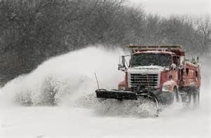
The New York City Office of Emergency Management today issued a hazardous travel advisory for Thursday, March 5, 2015.
The National Weather Service has issued a Winter Storm Warning for all of New York City from 7:00PM Wednesday evening through 7:00PM Thursday evening, March 5, 2015. Rain Wednesday evening will mix with or change to sleet and snow around midnight. The heaviest snow is expected early Thursday morning, with 2 to 4 inches of snow accumulation expected by the Thursday morning rush.
The snow will taper off Thursday afternoon. A total of 4 to 8 inches of snow accumulation is expected with this event. New Yorkers are asked to use mass transit where possible. Use caution when driving and allow for additional travel time, as roads will be dangerous due to the weather conditions
Meanwhile. US Forecasters are warning that a winter storm from the Mexican border in Texas to southern New England will continue to slam the nation through Thursday.
A widespread winter weather event is underway from southwest Texas into parts of southern New England. Most locations will see moderate to heavy rainfall before changing over during the overnight hours. Sleet and freezing rain are expected from south and central Texas into the Southeast while significant snowfall is expected from the southern Plains across the Mid-Atlantic into New England.
Heavy snow from the from parts of the Southeastern Ohio Valley to the Mid-Atlantic...
Rain and freezing rain from are falling in parts of the Lower Mississippi Valley to Southern Mid-Atlantic...
Temperatures be 10 to 30 degrees below average from the Great Lakes/Mid-Atlantic to the Lower Mississippi Valley and the Southern Plains...
A front extending from the Mid-Atlantic to the Central Gulf Coast will move southeastward to the Southern tip of Florida by Friday evening. Cold high pressure over the Upper Midwest to Southern High Plains will move eastward to the Mid-Atlantic to the Lower Mississippi Valley. A band of
moderate snow will develop along the northwest edge of the precipitation shield from parts of the Southern Ohio Valley to the Mid-Atlantic/Southern New England that will move southeastward to coastal Virginia by Thursday evening. In addition, a ribbon of rain/freezing rain and sleet will
develop over parts of the Lower Mississippi Valley to the Tennessee Valley will likewise move southeastward to parts of the Southern Mid-Atlantic Coast by Thursday evening. Light to moderate rain will develop over parts of the Western Gulf Coast/Central Gulf Coast that will follow suit and
move to the Southeast Coast by Thursday afternoon. Light rain will linger over the Southeast Coast and Florida through Friday.
Finally, high pressure weather will cover the Western U. S. through Friday. A front over Central Canada will move southward to near the U. S./Canadian Border by Friday evening producing light snow over parts of the Upper Mississippi Valley/Northern Plains and parts of the Upper Great Lakes.
Be Prepared
It’s important to be prepared during this time of year, so be sure to keep an emergency kit in your car that contains such necessities as an ice pick; a snow shovel and brush; a basic tool kit with screwdrivers, pliers and a wrench; a bag of traction material like kitty litter or sand; a flashlight with extra batteries; and items to keep you warm, like extra clothes, gloves, hats and Mylar thermal blankets (known as “space blankets”).
Finally, make sure your emergency kit contains booster cables and is well stocked with first-aid essentials and nonperishable food items, like granola and energy bars, water, warning flares and reflective triangles. If you don’t want to assemble a kit from scratch, you can easily buy already assembled emergency kits online.
Check Your Tires
Your tires are your main connection to the road, so be sure they are inflated properly. Underinflated tires provide less traction, can reduce fuel mileage and can wear out prematurely, so check your pressure at least once a month to ensure you’re driving on properly inflated tires.
As temps drop, so does the pressure in your tires—typically 1 pound per square inch for every 10 degrees Fahrenheit. Look for your vehicle’s correct tire pressure on an informative tag within the driver’s doorjamb or in your owner’s manual.
Depending on the conditions in your area, you may want to swap into winter tires; if not, ensure you have a safe tread depth for your road conditions.
If rain and wet roads are a concern, you should consider replacing your tires when they reach about 4/32″ of remaining tread depth, according to Consumer Reports. Use a quarter to check several tread grooves across each tire. If part ofWashington’s head is always covered by the tread, you have more than 4/32″ of tread depth remaining.
If sleet, slush and snow-covered roads are in your future, replace tires when they reach approximately 6/32″ of remaining tread depth to maintain good mobility. To check, place a penny into several tread grooves across the tire. If the top of the Lincoln Memorial is always covered by the tread, you have more than 6/32″ of tread depth remaining and should be safe for any sort of winter road conditions.
Remain Calm In a Skid
Be sure to increase following distances on ice and snow so that you have at least eight to 10 seconds (if not more) between yourself and vehicle in front of you; this will give you ample time to respond to road and weather hazards. Practice gentle acceleration and braking to maintain consistent traction in snowy and icy conditions; if your wheels begin to spin, release the accelerator until traction returns.
If your vehicle begins to slide or skid, do not panic! Look down the road in the direction you want to go and gently steer in that direction. Do not slam on the brakes, as that will upset the vehicle’s balance and make it harder to gain control.
If the rear wheels lose traction, continue to steer gently in the direction in which you want to travel to avoid a rear-wheel skid further in the opposite direction. Over-correcting and panic maneuvers can hinder your ability to regain control.
If the front wheels lose traction, it will be much harder to steer the vehicle. (Front-wheel skids are most frequently caused by hard braking or acceleration in vehicles equipped with front-wheel drive.) Wait for the front wheels to grip the road again; when traction returns, steer the wheels gently in the desired direction of travel.
Stay in Charge
A strong and fully charged battery is an absolute necessity in cold weather. Extreme temperatures can take their toll on your battery’s power, so if your battery is more than 3 years old, it may be time to consider replacing it before Jack Frost sucks out the last of its life. Also, be sure the connections are clean, tight and corrosion-free to ensure full-strength winter starts. Some commercial auto care centers will test your current car battery for free and sell you a new battery, if you need one. Some will also check your vehicle’s electrical system to ensure everything is in working order to ensure you will get years of hassle-free starts from your new car battery.
Step up to New Safety Technology
Practically every automaker offers electronic traction and stability control systems that work along with the car’s anti-lock braking system to assist drivers in slippery road conditions. Though they all use different trade names, these safety systems all function to help the driver maintain control in curves and turns — especially in wet or slippery conditions — by detecting when the vehicle begins to slip and reducing the throttle and applying the brakes to individual wheels to help correct the vehicle’s orientation. Traction systems also prevent the vehicle’s drive wheels from spinning while accelerating under slippery conditions.