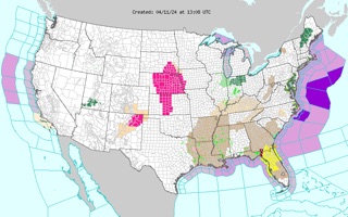
According to the National Weather Service anew wave of wet weather will bring back flooding for the Northeastern US region.
Rain, rain, go away
Don’t come back some other day
We want to stay dry inside
Do not cine again any other day
https://cimages.me/content/indoor-rain
Severe thunderstorms will shift into the Ohio Valley, Southeast, and Mid-Atlantic today. The main threats will be a few tornadoes, isolated large hail and damaging winds. Heavy rainfall will be possible from the southern/central Appalachians to the northern Mid-Atlantic.
The Naional Weather Service has issued another coastal flood advisory for southern Westchester County and southern Fairfield County, Connecticut from midnight to 5 a.m. Friday morning.
Rain began to fall around 2 a.m. this morning and left some low visibility conditions for commuters around 5 a.m. Some trees were also reported down in Westchester due to high winds, however no power outages have been reported by any local utility companies.
Expected rainfall amounts from today's storm could measure up to half an inch of rain through the evening and winds could average around 20 to 30 miles per hour, with high gusts potentially reaching up to 40 miles per hour.