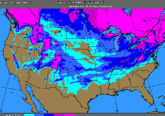
NOAA's site says that over half of the U.S. is snow-covered now. In fact, there has been snow on the ground in 48 of The United States of America. People in the Midwest, Northeast, South and West are all getting sick and tired of this cold weather.
A storm system and arctic cold front will bring winter weather to parts of the western and southern U.S. through Monday. Heavy snow will be possible across higher elevations from California into the Rockies. A wintry mix of snow, sleet, rain and freezing rain will be possible from New Mexico into the Gulf Coast states.
A mix of wintry precipitation expected across the southern Plains and into the Deep South. Heavy snow will continue to impact the central and southern Rockies. Arctic air will spread across the eastern half of the U.S.
An impressive Arctic high pressure will slide southward across the Plains and move eastward toward the East Coast. This cold air will continue to spill across the Four Corners, central and southern Plains, and the Deep South. Meanwhile, warm Gulf of Mexico moisture is filtering northward along the Gulf coast states. This is providing ripe conditions for a dangerous wintry mix of freezing rain and sleet especially across north Texas eastward into northern Georgia. The western edge of the precipitation will decrease in coverage by Monday afternoon. However, the threat of wintry mix impacting the Deep South will extend into Tuesday.
By Tuesday evening, precipitation will be mainly rain across the Gulf coast states. The central and southern Rockies will continue to see snow through Tuesday. The upper level low driving this winter storm will finally begin to move eastward late Monday night. Thus, the heaviest activity will occur from Monday into early Tuesday morning. By the time the upper low swings toward the Four Corners, the associated surface frontal system will move south into Mexico. This will deplete the moisture and consequently the threat of heavy snow. Snow showers can still be expected through
Tuesday evening but with less intensity.
A cold front will move across the Upper Great lakes by late Monday night and into early Tuesday morning. Snow showers ahead of the cold front can be expected. Upper Peninsula of Michigan will likely receive the bulk of the heavier snowfall activity. By Tuesday evening, the front will approach the Lower Great Lakes, and scattered snow showers will spread eastward as a result.