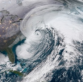
The weather outside is frightful for writers of this storm packing winds of might full https://youtu.be/869eu-DZzD4
This latest Nor'easter will impact many people from the Mid-Atlantic to the Northeast with threats including strong winds, heavy rains, and coastal flooding.
It this alone does not chill your bones, the temperatures will be cold enough to allow heavy snow in the higher elevations of New England and New York, where Winter Weather Advisories are in now in effect. Finally, the strongest winds are expected between 6A and 12 Noon.
The coastal storm will directly impact the NYC area today, then weaken as it lifts north of the area tonight into Sunday. Another weaker low will pass near the region on Monday.
High pressure builds across the eastern states on Tuesday and then offshore on Wednesday. The next frontal system impacts the area for the end of the week.
This particular nor'easter is a macro-scale cyclone. The name derives from the direction of the strongest winds that will be hitting an eastern seaboard of the northern hemisphere: as a cyclonic air mass rotates counterclockwise, winds tend to blow northeast-to-southwest over the region covered by the northwest quadrant of the cyclone.
Stay home, read some news stories http://science.doseofnews.com/ or perhaps take a shot at writing, or riding this one out.

